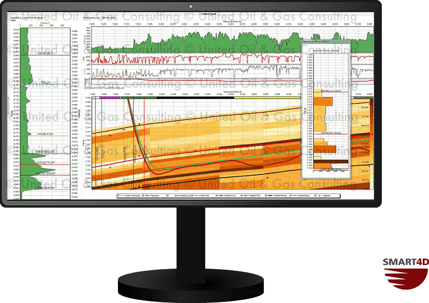
SMART4D’s unique Dynamic Profile tool displays a vertical cut through the property model along the horizontal well path. It is as if a vertical well were drilled along the well path, and the property (gamma, porosity or otherwise) is predicted from the model. This feature is particularly useful during the landing to view the approach of important structural markers and the true vertical depth (TVD).

The animation shows the horizontal panel with a dynamic profile of the gamma model. The green and red dots on the Dynamic Profile represent the driller’s plan and actual trajectory respectively.

Geosteering Features

Geosteering is the process of adjusting well placement while-drilling to improve overall well performance. StratCORR, Dynamic Profile, Target Planner, and other features are some the geosteering software features setting SMART4D apart.

Using the features of our Geosteering Software has proven to reduce drilling time, reduce dog-leg severity and increase well length in zone.

The 3D models created in SMART4D use automated data collected through WITSML. The software successfully combines the real time geology interpretation changes while-drilling, leveraging directional driller tools and sensors to provide an optimal well placement solution in a 3D environment.